GPS Field Area Measurement App
- 3.6
- Rating
- 1.00M
- Installs
- Free
- Price
 Analysis by App-foxy
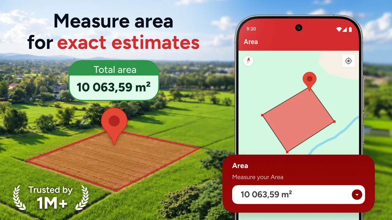
I found GPS Field Area Measurement App most useful when I treated it as a practical field notebook rather than a complete replacement for professional surveying equipment. It is a free Maps & Navigation app from Bizcraft Apps, built around measuring distance and land area through GPS. That simple purpose gives it a clear place in everyday tasks, especially when I need a quick estimate outdoors and do not want to sketch everything by hand.
The app has a 3.4 average from around 3.9 thousand ratings, and its audience is already fairly broad, with more than a million installs. Those figures suggest that it has reached people with very different expectations. In my experience, the strongest match is someone who wants a straightforward field measurement tool for gardens, plots, walking routes, outdoor planning, or rough property comparisons. It is less convincing for anyone who needs legally defensible boundaries, highly precise surveying, or a large set of specialist mapping controls.
How the app feels to read and navigate outdoors
The most important accessibility question for a GPS measurement app is whether I can understand what is happening while standing outside, often in bright light, moving between points, and paying attention to the ground. GPS Field Area Measurement App benefits from having a narrow purpose. I am not trying to learn a full geographic information system before taking a measurement. The idea is to use location information to build an outline or track a distance, then read the resulting estimate.
You May Also Like

 Blood Strike: 2.5 Anniversary
Blood Strike’s Loadouts Turn Every Drop Into a Tactical Gamble
A close look at Blood Strike’s custom loadouts: how fast access to signature weapons reshapes its battle royale rhythm, rewards preparation, and narrows the gap between fights.

 Pandora - Music & Podcasts
Pandora’s Music Is Easy to Start, but Harder to Recover
Pandora’s strength is its low-effort path from a seed to a station. Its weak spot is how much confidence it asks you to place in connection, setup, and quiet recovery.

 8 Ball Pool
 Is Built on Rivalries, Rematches, and Routine
A close look at the rivalries, rematches, shared routines, and unanswered safety questions that turn a quick pool match into a persistent mobile community.

 Samsung Music
’s Quiet Strength Is Playing What You Already Own
Its reach comes less from spectacle than from dependable access to a personal library. That simplicity is both the app’s strongest retention engine and its ceiling.

 AccuWeather: Weather Radar
AccuWeather Review: A Quick, Clear Forecast for Everyday Decisions
For everyday plans, the best forecast is the one you can understand quickly. AccuWeather makes rain timing, radar, and local conditions easy to act on, with a few trade-offs.

 Hill Climb Racing
Why Hill Climb Racing Still Turns Crashes Into One More Run
A tiny car, a bumpy hill and one more upgrade: Hill Climb Racing keeps resurfacing because its simple chaos makes every near-miss feel personal.
More From Our News Desk



That focused approach is helpful for people who prefer a small number of decisions on screen. A user who is comfortable with ordinary map apps should understand the general workflow quickly: position the phone, mark or follow the route, and inspect the calculated result. The experience is easier to approach than a professional mapping suite filled with layers, coordinate systems, and technical terminology.
At the same time, outdoor readability is not the same as indoor readability. Glare, reflections, rain, low contrast, and a phone held at an awkward angle can make any map interface harder to use. I would prepare the screen before starting a measurement rather than waiting until I am already at the far side of a field. Increasing the device’s text size or display contrast may help some users, although the result depends on the phone and operating system rather than on the app alone.
Navigation also depends on understanding whether I am placing points manually or relying on movement recorded by the phone. That distinction matters. Manual marking can be easier when I can see the boundary clearly, while walking with GPS may reduce tapping but introduces the need to keep the phone positioned consistently. Before measuring an important area, I would perform a short test around a familiar space. This is one of the best ways to discover how the app responds to movement, pauses, and a weak location signal.
The current version is 2.1.0, and it supports devices running Android 8.0 or later. That makes it available to many older Android phones, which is useful for people who keep a dependable outdoor handset instead of buying a new device for occasional measuring. Still, an older phone can have a smaller screen, slower location updates, or poorer visibility in sunlight. The app may run, but the overall experience can remain more demanding on that hardware.
Reading the result without overtrusting it
A measurement can look precise simply because it is displayed with several digits. I would not mistake visual precision for surveying accuracy. GPS can drift around trees, buildings, slopes, and other environments where the phone has difficulty receiving a clean location signal. When I need a planning estimate, that may be acceptable. When a fence line, sale, construction decision, or legal boundary depends on the result, I would use a qualified surveyor or a dedicated professional instrument instead.
One useful habit is to repeat the same measurement from a slightly different starting position. If the result changes noticeably, the area is telling me that the conditions or workflow are not stable enough for a confident conclusion. This is a practical accessibility improvement as well: users who find repeated walking or tapping tiring can identify uncertainty early instead of completing a long measurement that must be redone.
Motor, sensory, and cognitive demands in real use
GPS Field Area Measurement App can reduce the physical effort involved in estimating a large outdoor space because I do not need to carry a tape across the entire area. That is a meaningful advantage for people with limited stamina, balance difficulties, or pain that makes repeated long walks uncomfortable. A rough perimeter can be planned from a path, road edge, or accessible viewpoint instead of requiring constant manual measuring.
However, GPS does not remove all movement. If I want the phone to record a route while I walk, I still need to travel along or near the boundary. Uneven ground, mud, steep slopes, traffic, and dense vegetation can turn a simple measurement into a safety problem. For someone using a wheelchair, walking aid, or mobility scooter, the app may work best when the relevant boundary follows a driveable or paved route. It is not a substitute for an accessible route to every corner of a property.
Manual point placement creates a different motor challenge. Tapping small map controls, holding the phone steady, and correcting an accidental point can be difficult for users with tremors, reduced dexterity, or one-handed use. I would use a stable grip, pause before each tap, and avoid measuring while walking. A companion can also handle the phone while the user directs the boundary, which preserves the user’s decision-making without making the task depend entirely on precise finger control.
For users with visual impairments, a map-based measurement tool may be difficult to operate independently because the central information is spatial and visual. Screen magnification can make individual controls easier to see, but it can also reduce the visible map area and force more panning. A screen reader may identify some standard interface elements, yet I would not assume that every map point, boundary adjustment, or changing GPS position will be communicated clearly through speech. Anyone depending on audio-only feedback should test the complete workflow before relying on it in the field.
People with hearing loss are less likely to face a problem from spoken instructions because the core task is visual, but visual alerts can still be missed in glare or while concentrating on uneven ground. Users with light sensitivity may prefer a shaded location or a display setting that is comfortable for longer use. These are not special modes supplied by the app; they are sensible ways to adapt the phone around the app’s map-centered design.
A calmer workflow helps more than speed
I would divide a measurement into three stages: preparation, capture, and checking. During preparation, I would decide whether I am measuring a perimeter, a route, or a rough area estimate and make sure the phone is ready to use. During capture, I would stop before placing points rather than tapping while moving. During checking, I would look for obvious jumps, crossed lines, or a boundary that does not match the physical space.
This slower method is particularly useful for people who process information better when there are fewer simultaneous tasks. It also prevents a common mistake: trying to walk, watch the screen, avoid obstacles, and correct the outline at the same time. An app that saves a few seconds is not genuinely easier if the user has to rush. GPS Field Area Measurement App works better when I let the environment set the pace.
For a visually complex plot, I would use physical landmarks as checkpoints: a gate, a tree, a corner post, or a change in paving. That gives me something concrete to compare with the map. It is a simple but non-obvious safeguard against losing orientation, especially when the displayed position appears to drift and the actual boundary is irregular.
Situational access: where it helps and where it does not
The app’s strongest inclusive use case is a quick estimate in a place that is difficult to measure with a tape. Imagine a community gardener trying to plan planting beds on a large shared plot. Walking every edge with a measuring tape could be tiring, slow, and awkward around other beds. With a phone and a clear plan, the gardener can trace the usable section, compare approximate areas, and make an initial planting decision before asking for a more formal measurement.
A similar situation applies to a homeowner considering a lawn change. I could use the app to estimate the area that might need seed, paving, or ground cover, then use that estimate as a shopping guide. I would still add a sensible margin for waste and recheck the shape because a curved lawn, narrow side passage, or obstructed corner can make a simple outline misleading. The value here is not legal precision; it is reducing guesswork before spending money.
It can also help someone planning an outdoor activity. Measuring the distance of a proposed walk may make it easier to choose a manageable route for a mixed-ability group. Yet the distance alone does not tell me whether the route has steps, steep gradients, poor surfaces, or safe resting points. I would treat the result as one planning input and inspect the route separately. For wheelchair users or people with limited stamina, an accessible short route may be a better choice than a longer route that looks attractive on the map.
In agricultural or rural settings, the app may be convenient for an initial estimate of a field or section. The trade-off is that open land can still produce inconsistent GPS results, particularly when I am trying to follow a boundary that is not visually obvious. I would take several readings when the decision matters and keep the phone position as consistent as possible. A professional measurement remains the better option for contracts, compliance, or disputes.
The app is less suitable in dense urban areas when tall buildings interfere with location accuracy or when walking along a boundary would be unsafe. It is also a poor fit for measuring an interior room, because GPS is designed for outdoor positioning and does not replace a tape measure or indoor laser tool. Likewise, if the task requires detailed property lines, elevation, map layers, or formal records, I would choose a specialist mapping or surveying solution instead.
Comparing it with familiar alternatives
Compared with a tape measure, GPS Field Area Measurement App is more practical for large or irregular outdoor spaces, but the tape is often more dependable for short, straight distances. A tape also gives immediate physical feedback and does not depend on satellite positioning. For a small garden bed, room, or fence section, I would probably reach for the tape first.
Compared with ordinary map applications, this app is more focused on turning location into an area or distance estimate. A general map app may be better for discovering places, following directions, checking traffic, or sharing a route. This tool makes more sense when measurement is the main reason I have opened the phone. The narrower purpose can make the task less distracting, though it also means I should not expect the broader navigation features of a full map service.
Compared with professional surveying software, the advantage is approachability. I can use a phone-based workflow without learning technical mapping concepts. The disadvantage is confidence: a convenient estimate is not automatically a certified measurement. This distinction should guide the decision more than the number shown on screen.
Remaining barriers and practical cautions
The biggest barrier is the dependence on the phone’s location behavior and the user’s ability to interpret a map. Someone may complete every tap correctly and still receive a poor result because of environmental conditions. I would avoid treating a single pass as final, especially near buildings, heavy tree cover, narrow valleys, or other places where the phone’s position may wander.
Another barrier is the need to manage the device while outdoors. Bright sunlight, cold hands, wet fingers, gloves, and a phone case can all make tapping less comfortable. A user with limited dexterity may need a companion or a stylus that works with the device. I would not hold the phone in a way that blocks safe walking or distracts me near roads, water, slopes, or machinery.
Cost is easy to misunderstand. The app itself is free, but it includes in-app purchases ranging from $0.99 to $99.99 per item. I would check the purchase screen carefully before confirming anything, particularly if a child or another family member shares the device. The free entry point is useful for trying the basic experience, but users should decide whether any optional spending is appropriate before building the app into a regular workflow.
The Everyone content rating makes the app broadly suitable from a content perspective, but that does not mean every outdoor task is suitable for every age or ability without supervision. A child can understand the idea of measuring a garden, while an adult should still handle roads, private property, water edges, and any situation where distraction could cause harm.
There is also a privacy and planning consideration whenever a phone is used to record or display a location. I would avoid casually sharing screenshots or measurements that reveal a private home, a vulnerable person’s routine, or the layout of a restricted site. The app’s usefulness should not encourage careless disclosure of places that someone has a reason to keep private.
My inclusive verdict after using it
GPS Field Area Measurement App is a sensible choice for people who want a focused outdoor measuring aid and are comfortable adapting their phone to the conditions. I like that its purpose is easy to explain: use GPS to estimate distance or area without dragging a long tape across a large space. That can make planning more reachable for users who find extensive walking, bending, or carrying equipment difficult.
My recommendation comes with a clear boundary. I would use it for garden planning, rough material estimates, route preparation, outdoor projects, and early-stage comparisons. I would not use it as the sole authority for a legal boundary, a high-stakes construction decision, an exact survey, or an inaccessible route assessment. In those cases, a professional measurement or an on-site accessibility check is worth the extra effort.
The best results come from a deliberate workflow: choose a safe location, use landmarks, pause before tapping, repeat important measurements, and read the result as an estimate rather than a guarantee. Those habits make the app more useful for people with different physical and sensory needs because they reduce speed, confusion, and unnecessary movement.
Bizcraft Apps has kept the product centered on a practical Maps & Navigation task, and that focus is its main strength. The experience is not universally effortless, especially for users who depend on audio guidance, have difficulty with small touch targets, or work in challenging GPS environments. Still, for an outdoor user who wants a free starting point on a compatible Android device, GPS Field Area Measurement App offers a convenient way to turn a phone into a rough field measuring tool. I would recommend trying it on a familiar, low-risk space first; that small test will quickly show whether its visual workflow and GPS behavior suit the person who plans to rely on it.
FAQs for GPS Field Area Measurement App
01What is the primary function of the GPS Field Area Measurement app?
The GPS Field Area Measurement app is designed to measure land areas and distances accurately using GPS technology. It is particularly useful for farmers, surveyors, and real estate professionals who need precise measurements for fields, plots, or any land area. The app provides real-time data and supports various measurement units.
02Does the app work offline, or is an internet connection required?
The GPS Field Area Measurement app primarily relies on GPS data, which means it can work offline in areas with limited or no internet connectivity. However, some features like map overlays or updates may require an internet connection. Users should ensure their device's GPS is enabled for optimal performance.
03How accurate are the measurements provided by the app?
The accuracy of the GPS Field Area Measurement app depends on the device's GPS capabilities and signal strength. Generally, it offers high precision, but factors such as atmospheric conditions, obstructions, and device quality can affect accuracy. Users can improve results by ensuring clear skies and minimal obstructions during measurements.
04Is the GPS Field Area Measurement app user-friendly for beginners?
Yes, the app is designed with an intuitive interface, making it accessible to beginners. It features easy-to-follow guides and tutorials, ensuring users can quickly learn to navigate and utilize its functions. The app includes helpful tooltips and support to assist users in getting accurate results without prior experience.
05Are there any subscription fees or in-app purchases associated with the app?
The GPS Field Area Measurement app may offer both free and premium features. While the basic functions are often free, advanced tools or additional features might require a one-time purchase or subscription. Users should check the app description in the app store for detailed pricing and feature information before downloading.
Pros
- Accurate area measurements for any field.
- User-friendly interface with clear visuals.
- Supports multiple units of measurement.
- Offline functionality for remote locations.
- Comprehensive history tracking of measured areas.
Cons
- Limited features in free version.
- Battery usage can be high during operation.
- Requires GPS signal for precise measurements.
- Ads may disrupt user experience.
- No integration with other mapping tools.

GPS Field Area Measurement App
Gallery